


What's the Hourly Rate for a property survey cost?
chueh
12 years ago
Featured Answer
Sort by:Oldest
Comments (21)

cheerpeople
12 years agoRelated Professionals
North Chicago Architects & Building Designers · Vancouver Architects & Building Designers · Harrisburg Home Builders · Ives Estates Home Builders · Kaysville Home Builders · Lodi Home Builders · Monticello Home Builders · Royal Palm Beach Home Builders · Abington General Contractors · Bartlesville General Contractors · Martinsville General Contractors · Norristown General Contractors · Ravenna General Contractors · Sauk Village General Contractors · West Whittier-Los Nietos General Contractorscheerpeople
12 years agodekeoboe
12 years agodhuston
12 years agodavid_cary
12 years agoeoz3106
12 years agoshifrbv
12 years agobus_driver
12 years agoash6181
12 years agobrickeyee
12 years agolavender_lass
12 years agoUser
12 years agojuniork
12 years agochueh
12 years agoaj33
12 years agobrickeyee
12 years agochueh
12 years agochueh
12 years agonycefarm_gw
12 years agobrickeyee
12 years ago
Related Stories
INSIDE HOUZZHouzz Survey: See the Latest Benchmarks on Remodeling Costs and More
The annual Houzz & Home survey reveals what you can expect to pay for a renovation project and how long it may take
Full Story
REMODELING GUIDESHouzz Survey Results: Remodeling Likely to Trump Selling in 2014
Most homeowners say they’re staying put for now, and investing in features to help them live better and love their homes more
Full Story
REMODELING GUIDESHouzz Survey: Renovations Are Up in 2013
Home improvement projects are on the rise, with kitchens and baths still topping the popularity chart
Full Story
GARDENING AND LANDSCAPINGHouzz Survey: See What Homeowners Are Doing With Their Landscapes Now
Homeowners are busy putting in low-maintenance landscapes designed for outdoor living, according to the 2015 Houzz landscaping survey
Full Story
FUN HOUZZSurvey Says: We’re Scared of Being Home Alone — and Spiders
A new Houzz survey reveals that most of us get spooked in an empty house. Find out what’s causing the heebie-jeebies
Full Story
FEEL-GOOD HOMEWhat Really Makes Us Happy at Home? Find Out From a New Houzz Survey
Great design has a powerful impact on our happiness in our homes. So do good cooking smells, family conversations and, yes, big-screen TVs
Full Story
INSIDE HOUZZDecorating Trends: A New Houzz Survey Shows What Homeowners Want
Is the TV gaining or losing ground? Are women or men trendier? Find out and learn more about people’s decorating plans right here
Full Story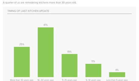
KITCHEN DESIGNSurvey Results: Kitchen Trends That Seem Here to Stay
More than a third of respondents in Houzz’s annual kitchen trends report now have the means to remodel. Here’s what else they told us
Full StoryREMODELING GUIDESBathroom Remodel Insight: A Houzz Survey Reveals Homeowners’ Plans
Tub or shower? What finish for your fixtures? Find out what bathroom features are popular — and the differences by age group
Full Story
INSIDE HOUZZA New Houzz Survey Reveals What You Really Want in Your Kitchen
Discover what Houzzers are planning for their new kitchens and which features are falling off the design radar
Full StoryMore Discussions

chuehOriginal Author